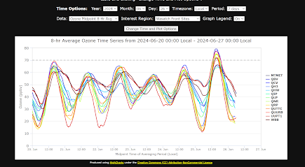
We have had off and on ridging aloft throughout much of June. June 25 is the first day with 8-h average ozone greater than 70 ppb at many stations. Hourly averages from Hawthorne during the month shown below. See graphics at Horel - Real-Time (utah.edu) for much of the information shown below.
8-h Averages during the past week at stations in the Salt Lake Valley.
Many days during the month had well-defined lake breezes during the afternoon with delayed onset of high ozone in the southern valley. That often led to later afternoon peaks in the southern end of the valley. On June 25th northerly flow became established earlier in the morning with delayed high ozone only in the far southern valley. The following sequence of ozone observations spans the period from 4AM to 5 PM. Note the high background ozone concentrations during early morning adjacent to the Wasatch. Bountiful (QBV) peaks earliest with much of the SL Valley exceeding 70 ppb during the late afternoon.
0.5 degree radar imagery from the TDWR (reflectivity on the left, radial wind speeds on the right) help to illustrate the initial penetration of the lake breeze into the northwest corner of the SL Valley. Cyan colors in the SL valley are inbound to the radar north of the airport. Orange shades denote outbound (more northerly winds).


.jpg)


No comments:
Post a Comment